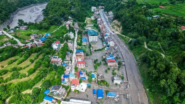
Amassive flash flood originating in Tibet swept into central Nepal on Wednesday, killing more than 160 people as search and rescue efforts to locate the hundreds missing continue.
The flash flood washed away important bridges, damaged roads and disrupted hydropower projects as torrents of water, mud, rocks and debris moved downstream.
The disaster was initially believed to have been triggered by an earthquake. But the US Geological Survey (USGS) later clarified that no earthquake had occurred. Instead, the seismic activity recorded in the region was caused by a massive glacial collapse and debris flow in Tibet, which set off the chain of events that led to the deadly flooding in Nepal.
The USGS initially recorded the event at around 8:37 am Nepal time on Wednesday and classified it as a magnitude 4.4 earthquake near the Nepal-China border, north of Kathmandu.
After analysing data from nearby seismic stations, long-period seismic waves and satellite imagery, the agency revised its assessment. It said the event was actually a glacial collapse and debris flow that caused catastrophic impacts downstream.
What happened in Tibet?
The disaster began with a huge mass of ice and rock collapsing from the mountain in Tibet and plunging into the valley below.
The force of the collapse was powerful enough to produce seismic waves, which were initially detected as an earthquake. The event was later estimated to have generated seismic activity equivalent to around a magnitude 4.4 event.
But the ground shaking was not caused by tectonic movement.
An initial analysis of Planet Labs satellite imagery found that an ice-and-rock landslide triggered a debris-laden flood in the Lhende River (high-altitude mountain stream flowing from Tibet), around 20 km northeast of the Rasuwagadhi Nepal-China border crossing.
The Lhende River, or Lhende Khola, is a tributary of the Bhote Koshi River, which flows from Tibet into Nepal.
How did the glacial collapse trigger the Nepal flood?
The enormous amount of ice, rock and debris that crashed into the river blocked its flow, effectively forming a temporary natural dam.
Water then accumulated behind the blockage.
When the obstruction eventually gave way, the stored water was suddenly released along with the debris. The surge entered the Bhote Koshi River and swept into Nepal with enormous force.
Why was it initially reported as an earthquake?
In the immediate aftermath, the cause of the disaster was not clear.
The seismic activity detected at around 8:37 am was initially classified as a 4.4-magnitude earthquake. Nepal’s Foreign Minister Shishir Khanal also initially said an earthquake may have triggered a landslide, which then blocked the river and sent water rushing downstream.
Other possible explanations included a glacial lake outburst flood (GLOF) or an ice avalanche, AFP reported.
The USGS later reviewed the available evidence and reached a different conclusion.
The agency said the seismic event initially reported as an earthquake was actually caused by a glacial collapse and debris flow. “No earthquake had occurred,” the USGS clarified.
Was this a Glacial Lake Outburst Flood?
The event involved a glacial hazard similar to those that can produce a glacial lake outburst flood, although the USGS specifically identified the Nepal disaster as a glacial collapse and debris flow.
A GLOF occurs when a natural dam holding back a glacial lake suddenly fails. The dam may consist of ice, rocks or loose sediment. Once it breaks, a large volume of water can rush downstream, often carrying rocks, mud and other debris.
Such failures can occur because of erosion, rising water pressure, avalanches, rockfalls, earthquakes or the sudden collapse of ice and rock into a glacial lake.
In this case, the immediate trigger identified by the USGS was the glacial collapse and debris flow in Tibet, which blocked the river before the resulting surge moved downstream into Nepal.
The flood devastated central Nepal
After crossing into Nepal, the flood surged through the Bhote Koshi River, affecting areas including Rasuwa, Dhading and Nuwakot before continuing downstream.
The destruction was widespread.
Videos from the affected areas showed muddy water packed with rocks and debris sweeping through settlements. Bridges collapsed under the force of the current, vehicles were carried away and buildings were submerged or destroyed.
The flood also damaged critical infrastructure, including roads and hydropower facilities.
Why a glacial collapse can be so dangerous
The Nepal disaster shows how quickly a high-altitude event in Tibet can turn into a major disaster downstream.
A collapse involving a huge amount of ice and rock can obstruct a river almost instantly. If the blockage then fails, the resulting surge can travel rapidly downstream, carrying enormous quantities of water and debris with it.
A 2023 study estimated that around 15 million people worldwide are exposed to glacial lake outburst flood hazards, with large populations at risk in China, India, Nepal, Pakistan and Peru.