Each time the Kheer Gad river awakens, the villagers don’t run—they climb to their rooftops and wait, not for rescue, but to witness what remnants the waters decide to spare.
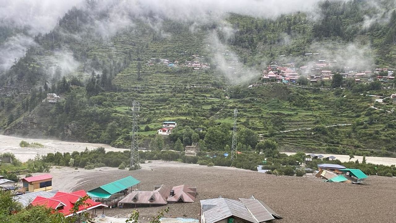
In the remote village of Dharali, nestled along the ancient Indo-Tibetan Silk Route near Gangotri, calamity isn’t an exception—it’s the terrain’s native language. Each time the Kheer Gad river awakens, the villagers don’t run—they climb to their rooftops and wait, not for rescue, but to witness what’s left standing when the river leaves. The river doesn’t offer a warning. There’s no thunder or heavy downpour. It arrives unannounced, pulling centuries of Himalayan stone in its grasp. This isn’t an event—it’s a season. In Dharali, floods are not measured in centimetres of rain, but in memories of loss.
Inside Uttarkashi’s Seasonal Nightmare
Residents recount the deluges like they do festivals—2010, when the school walls were soaked; 2012, when a shop vanished overnight; 2018, when entire apple orchards were crushed beneath boulders. For most of the year, the Kheer Gad seems gentle—a stream beneath the shadow of Srikanth Parvat. But during cloudbursts, it doesn’t rise, it roars.
Yet, even amidst repeated devastation, Dharali defied death until now. Between 2010 and 2018, the floods snatched homes, roads, livelihoods, and landscapes—but not lives. The village, home to just over 500 souls, sits along the Char Dham yatra route, just 20 km shy of Gangotri shrine. In summer, pilgrims and tourists flood in, doubling its population. But come mid-July, the villagers turn their gaze skyward and listen for the river’s roar.
The 2018 flood, until recently the worst in living memory left behind silence. Nearly two dozen homes and dhabas crumbled, apple orchards vanished, and the sacred path to Gangotri was strangled by broken roofs and sludge.
“We dug out furniture from mud two days later,” recalled Lokendra Bisht, a local from Uttarkashi. “That time, no one died. But the loss – of homes, of work – it stayed with us longer than the flood.” His memory of 2012 was no less haunting. The river surged once again, ripping through shops and homes, its fury sudden and merciless.
With every passing year, the Kheer Gad’s nature has shifted—from a stream to a live wire, unpredictable and always ready to explode. The debris it hurls creeps closer and closer to the village heart. Though its course from Srikanth Parvat to the Bhagirathi River is short, its force is devastating. When it floods, Dharali drowns in chaos.
In 1978, a dam burst near Dabrani sent torrents crashing into nearby hamlets. In 1984, a cloudburst over Gyansu nala transformed fertile fields into desolate silt plains overnight. And in 2003, Varunavat mountain split apart, swallowing homes and severing roads in Uttarkashi. Dharali escaped each time.
Warnings ignored?
A 2013 report by the Uttarakhand Disaster Mitigation and Management Centre flagged Dharali and neighbouring villages—Sukhi and Jhala—as high-risk zones. But while nature cautioned, development barged forward. Hotels mushroomed on fragile riverbeds. Roads were cut wider. Slopes were butchered to make way for pilgrimage.
Geologists have been sounding the alarm for years. With glaciers melting and monsoon rhythms becoming erratic, cloudbursts are no longer rare—they are routine. As one expert from the Wadia Institute ominously stated, “People think the mountain breaks in one night. But in reality, it’s been breaking slowly for years.”