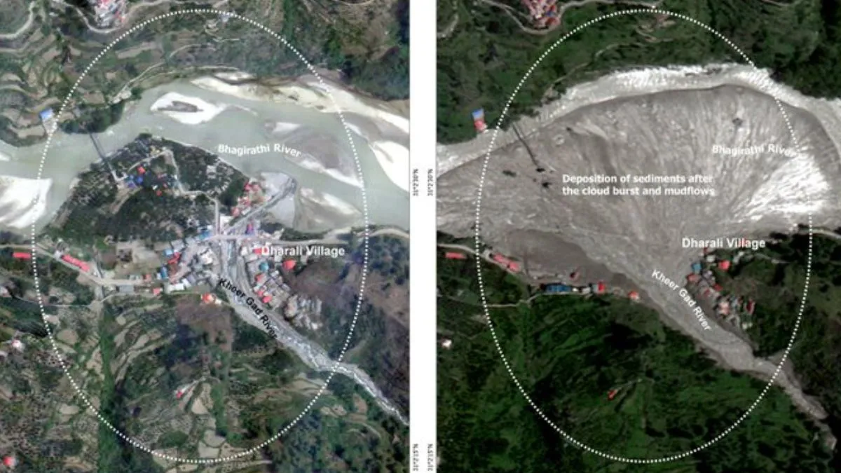
The Indian Space Research Organisation (ISRO) on August 7 shared satellite images showing the disappearance of buildings, roads and plantations in Dharali and Harshil villages of Uttarkhand, days after a cloudburst triggered flash floods, claiming the lives of five people and leaving several missing. The satellite images shared by ISRO on X reveal submerged buildings, debris spread, and an altered Kheer Ganga river path.
The ISRO used Cartosat-2S satellite imagery to reveal side-by-side comparisons of before and after conditions (comparing data of June 13, 2024, and August 7, 2025) of Dharali and Harshil villages. In the satellite images, a pronounced fan-shaped debris and sediment deposit, covering approximately 20 hectares, is visible near the confluence of Kheer Ganga and Bhagirathi River. This deposit engulfed much of the village areas, burying buildings and plantations under debris.
Satellite Insights Aiding Rescue & Relief Ops
ISRO/NRSC used Cartosat-2S data to assess the devastating Aug 5 flash flood in Dharali & Harsil, Uttarakhand.
High-res imagery reveals submerged buildings, debris spread (~20ha), & altered river paths, vital for rescue teams on… pic.twitter.com/ZK0u50NnYF
— ISRO (@isro) August 7, 2025
The flash flood altered the topography of Uttarakhand as the river appears to have significantly widened, and the river morphology has been shifted. Many buildings and structures seem to be partially or entirely submerged, and some of the structures seem to have disappeared from their locations.
ALSO READ: Election Commission Plans New Series Of EPIC Numbers To Curb Duplication Issue; What Is IT
“The event highlights increasing vulnerability of Himalayan settlements to disasters. Scientific analysis is being carried out to ascertain the cause of the triggering event,” ISRO stated.
Rescue Opn Underway In Uttarkashi
According to the officials, at least five people were killed and several went missing after a cloudburst struck Uttarkashi district of Uttarakhand on Tuesday. As the weather conditions improved on Thursday, rescue and relief efforts gained pace. 270 stranded individuals were rescued from different locations, while several others are yet to be located.