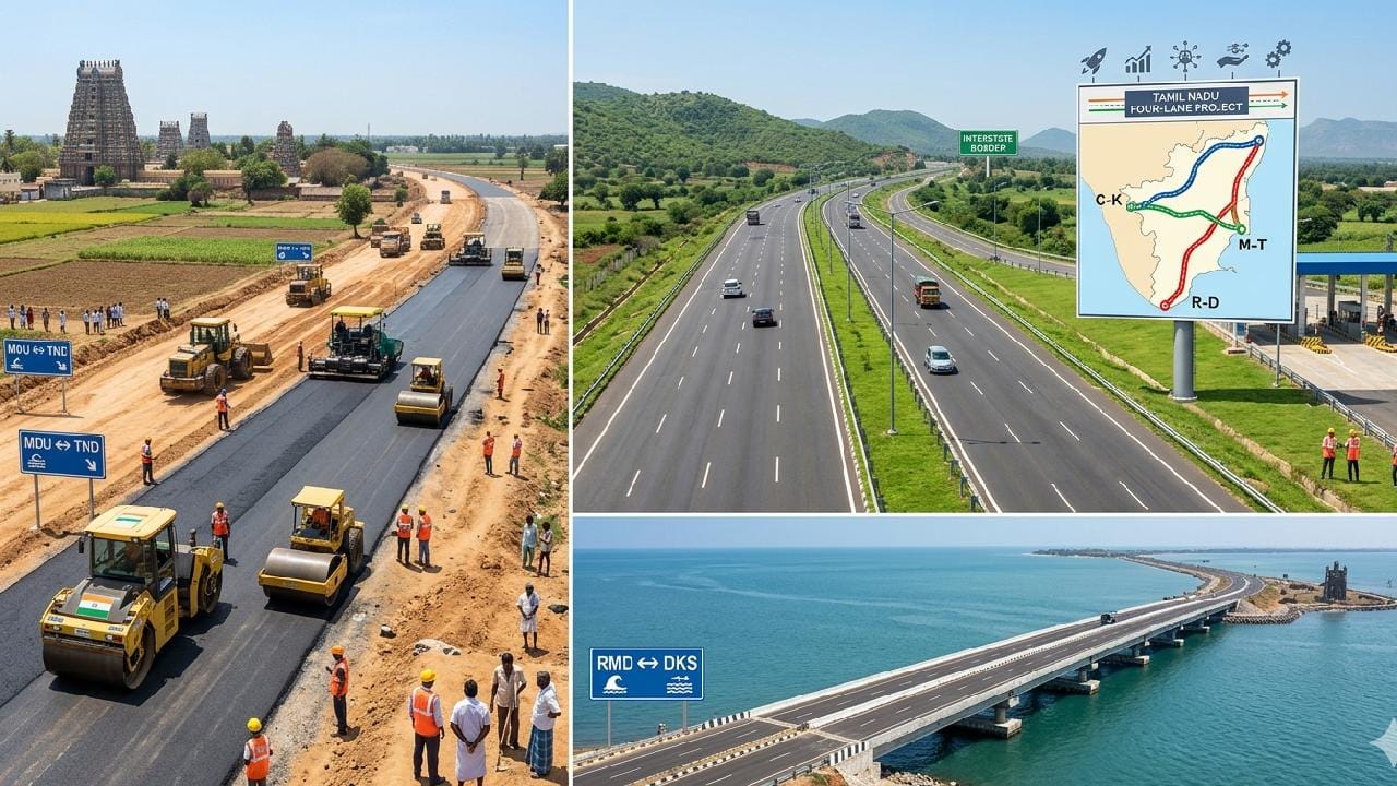
Chennai: The National Highways Authority of India (NHAI) is gearing up for a massive leap forward in Tamil Nadu’s road infrastructure, with work on preparing Detailed Project Reports for three key highway projects gaining significant momentum. These corridors, once upgraded to four-lane highways, are expected to reduce travel times by half and accelerate economic growth across the regions they traverse.
Kerala–Tamil Nadu border to East Coast (NH-85): A 225-Km trade corridor
The 225-kilometer stretch from the Kerala border, passing through Madurai and extending up to Thondi, is set to be transformed into a four-lane highway. This road serves as a crucial trade corridor connecting the Western Ghats with the East Coast. Originating in Kochi, Kerala, and terminating at Thondi—a coastal town on Tamil Nadu’s eastern seaboard—the Tamil Nadu sector spans approximately 225 kilometers.
Key towns along the route include Bodinayakanur, Theni, Andipatti, Usilampatti, Madurai, Thiruppuvanam, Sivaganga, Kalayarkovil, and Thondi. Centered around Madurai, this highway functions as a vital commercial artery linking the Western Ghats with the Bay of Bengal. Once completed, the project is expected to accelerate freight movement across southern Tamil Nadu at a phenomenal pace.
Coimbatore – Karnataka Border (NH-948): The Kongu region’s dream route
The 120-kilometer stretch connecting Coimbatore—Tamil Nadu’s industrial capital—to the Karnataka border is slated for expansion into a four-lane highway. This road serves as the traditional route connecting Coimbatore to Bengaluru. Traversing the Thimbam Ghats and the Sathyamangalam forest reserve, the highway project has been designed by the NHAI to simultaneously maintain ecological balance while effectively alleviating traffic congestion.
Within Tamil Nadu, the route spans approximately 120 kilometers, passing through Coimbatore (Saravanampatti), Kovilpalayam, Annur, Puliyampatti, Sathyamangalam, Bannari, Thimbam Ghat Road, Asanur, and Punjanur at the Karnataka border. The route traverses the Sathyamangalam Tiger Reserve and the Thimbam Ghat Road, which features 27 hairpin bends. This initiative is poised to bring about a revolutionary reduction in travel time between Bengaluru and Coimbatore.
Ramanathapuram – Dhanushkodi (NH-87): Where spirituality and history converge
The 74-kilometer stretch extending from Ramanathapuram to Dhanushkodi—India’s southernmost tip—is being upgraded into a four-lane highway. Forming a segment of the Madurai–Dhanushkodi corridor, this route extends from Ramanathapuram all the way to Arichal Munai, the point where the Indian landmass ends.
Key towns along the route include Ramanathapuram, Mandapam, Pamban Bridge, Rameswaram, Dhanushkodi, and Arichal Munai. Beyond its significance for spiritual pilgrims, this route holds historical importance as the “Last Road of India”—the closest point of access to Sri Lanka. The road is being constructed using state-of-the-art technology specifically designed to withstand the vagaries of the sea. Given the year-on-year increase in tourist arrivals to Dhanushkodi, this project is poised to completely transform the landscape of Rameswaram Island.
Project Status and expected impact
The NHAI has currently invited tenders for the preparation of Detailed Project Reports for all three projects. Construction work will commence once studies regarding soil testing, land surveys, and environmental impact assessments are completed.
Once these roads are successfully upgraded to four-lane highways, it is anticipated that traffic congestion will be significantly alleviated and travel times will be reduced by half. The transformation of these three key corridors is expected to not only reduce travel distances but also manifold the growth of the real estate and industrial sectors in the regions they serve.