India is set for above-normal rainfall in September, says IMD, warning of floods and landslides in Uttarakhand, Delhi, Haryana, Rajasthan and other regions. The country has already recorded surplus rain this monsoon season.
India is set for a wetter-than-usual September, the India Meteorological Department (IMD) has forecast, capping a monsoon season that has already brought devastating floods, cloudbursts and landslides across several states. IMD chief Mrutyunjay Mohapatra on Sunday said that the country could receive rainfall exceeding 109 per cent of the long-period average (167.9 mm) for the month.
What the Forecast Says
According to the IMD, most regions are expected to record normal to above-normal rainfall. However, some parts of the northeast and east, along with the southernmost parts of peninsular India and a few pockets in northwest India, are likely to see below-normal rain.
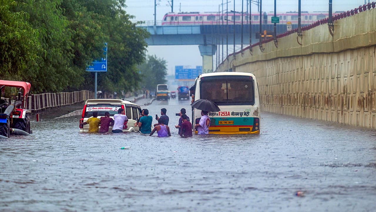
Mohapatra, addressing an online press briefing, cautioned that heavy spells in September may spark fresh landslides and flash floods in Uttarakhand. He also flagged the possibility of flooding disrupting daily life in Delhi, south Haryana and north Rajasthan.
“Many rivers originate in Uttarakhand. So, heavy rainfall means flooding downstream, impacting cities and towns. We must keep this in mind,” Mohapatra said.
Record-Breaking August Rains
Data shows that between June 1 and August 31, India received 743.1 mm of rainfall, about 6 per cent above normal.
- June: 180 mm, 9% above normal, with surpluses in northwest and central India.
- July: 294.1 mm, 5% above normal, driven by a 22% surplus in central India.
- August: 268.1 mm, 5.2% above normal.
In August, northwest India received 265 mm — the highest for the month since 2001 and the 13th highest since 1901. Cumulatively, the region has recorded 614.2 mm this monsoon, a 27% surplus.
Southern peninsular India too had a soggy August, logging 250.6 mm of rainfall, which was 31% above normal — the third highest since 2001.
Why September Rains Are Rising
Interestingly, Mohapatra noted that September rainfall has been showing an increasing trend since 1980, barring a few weak monsoons in 1986, 1991, 2001, 2004, 2010, 2015 and 2019.
The IMD has officially shifted the normal monsoon withdrawal date from September 1 to September 17 — an indicator that the month is now more active.
“September is a transitional phase. With delayed withdrawal, monsoon winds often clash with incoming western disturbances. Their interaction increases rainfall activity. This explains the rising September trend,” the IMD chief explained.
Rivers in Spate, Hills in Danger
This monsoon has already brought some of the worst floods in Punjab in decades, inundating thousands of hectares of farmland and displacing lakhs of people.
In the Himalayan belt — Himachal Pradesh, Uttarakhand and Jammu & Kashmir — back-to-back cloudbursts and flash floods have caused widespread destruction. Dharali in Uttarakhand, Kishtwar in J&K, and Himachal’s Mandi were among the worst hit in August.
Between July 28 and August 14, active western disturbances triggered heavy rainfall over the western Himalayas, including a flash flood in Uttarkashi (August 5) and major riverine floods in Uttar Pradesh and Bihar.
From August 21 to 27, successive disturbances coupled with strong monsoon winds unleashed “extremely heavy rainfall” over Punjab, Haryana, east Rajasthan, Jammu and Kashmir, while parts of Telangana and Maharashtra also recorded torrential downpours.
Cloudbursts and Mini Cloudbursts
While the IMD says there is no clear rise in cloudburst incidents, studies show a worrying increase in mini-cloudbursts — defined as rainfall of more than 5 cm in an hour.
This trend, experts say, is likely to amplify the risks for the fragile Himalayan states where even a few hours of intense rain can trigger catastrophic landslides.
With above-normal September rainfall on the cards, the IMD has urged state governments and disaster management agencies to remain on high alert, especially in flood-prone areas and hilly terrains.
For millions of people living in river basins and Himalayan towns, the final leg of this year’s monsoon may decide whether 2025 will be remembered as a year of surplus rain — or yet another season of destruction.