New Delhi: Flood magnitude has decreased in nearly three-fourths of the country in the 40-year period between 1970 and 2010 as compared to the previous 100 years even though flood intensity has increased in early or pre-monsoon period in north-western Himalayan and Malabar region in peninsular India, according to a new study based on water flow data from 173 gauges across India.
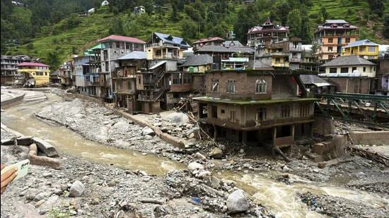
The study, ‘The changing magnitude and timing of riverine floods in India’, published last week in peer reviewed journal, Nature, comes at the time when flash floods caused by extreme rainfall have caused death of 148 persons in Himachal (78) and Uttarakhand (70) since the onset of monsoon on June 1. Most of these deaths have taken place in the later part of June and the first week of July.
The study said flooding due to flash floods in the higher reaches of Ganga and Indus regions was happening in the early monsoon period as compared to monsoon between July and September. This, the study said, could have “catastrophic outcomes” since the entire flood management system needs to be redesigned to change in the flooding pattern.
A possible reason for higher frequency of early flash floods is climate change induced alteration in the rain-snow transition zone in the higher reaches which could advance spring/pre-monsoon flood peaks by several weeks in snowmelt-dominated regions, the study said.
Another region where the flood intensity has increased by eight percent per decade during the study period was in the west flowing rivers from Tadri to Kanyakumari (Chaliyar, Periyar, Bharathapuzha, Vamanapuram, etc.) in the Malabar coast and it was associated with intensified pre-monsoon rainfall.
“Increasing discharges and early floods on the Malabar coast in the pre-monsoon season may have severe implications for agriculture, as it is a significant crop harvesting time,” the joint study by the Indian Institute of Technology (IIT) Delhi and IIT-Roorkee said.
Monsoon season accounts for 80% of India’s annual rainfall and floods are a common occurrence in this season. Floods have killed 113,390 people between 1975 and 2015, averaging 2,765 deaths per year. In this study, 85% of the floods identified across all stations were recorded during the monsoon season between June and September.
The study, which did not cover north-eastern India, said that 74% (128) of the 173 gauging stations studied showed a declining trend in flood magnitude with 47 showing “significant” decrease. In contrast, only 26% (45) of the gauging stations showed an increasing trend and only four stations showed a “significant” increase.
In the main Ganga basin, which is home to about 40% of India’s population, the study recorded a 17% per decade decline in the flood magnitude. The Central Ganga basin, which covers large parts of Uttar Pradesh and southern Bihar, recorded maximum fall in the flood magnitude.
“The inference is that the 100-year flood discharge has decreased by more than half during these 40 years at many locations in the western and central Ganga basin,” the study said.
The authors said that the decreasing flood magnitudes in the Ganga basin was “strongly” linked to declining soil moisture and monsoon precipitation influenced by Indian Ocean warming and atmospheric aerosols in the region.
However, the flooding in the eastern upper Ganga region covering Kosi river basin showed a significant trend towards later floods without much change in flood intensity.
The flood magnitude has also declined in Narmada basin that covers a large part of Gujarat and Madhya Pradesh primarily because of the “construction of dams” in this region during the study period.
The study found that in the Marathwada region of the Deccan plateau, which has been experiencing severe droughts in recent times, river flows were found to be decreasing at an average rate of 8% per decade during the monsoon season and 31% in pre-monsoon.
The study found a clear relationship between the catchment area and the observed percentage change in flood magnitude per decade.
The flood magnitudes over larger catchments are decreasing at higher rates, and as the catchment size decreases, the rate of change is also decreasing, the study said, highlighting the role the dams (which are mostly on big rivers) play in reducing the flood intensity.
“The construction of large dams and reservoirs, which are more prevalent in larger catchments…has been shown to attenuate flood peaks in existing studies,” the study said. However, the study cautioned that dams if they are improperly operated may aggravate flooding.
The study said if these changes in the flood magnitude and timing trends are not fully understood, significant economic and environmental consequences could emerge, given that reservoir filling, ecosystems, and communities are adapted to the typical seasonal flooding patterns.
For instance, diminished flood magnitudes can lead to lower reservoir fillings, adversely impacting water supply, irrigation, and hydropower generation, the study said, highlighting that similar shifting in flooding has been recorded in other monsoon areas such as Mekong, Peninsular Malaysia, Sumatra and Yangtze river valley in China.