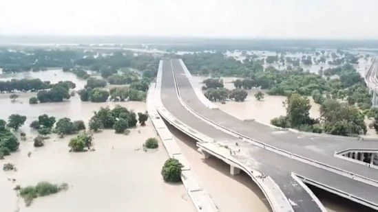
After days of incessant rain in Delhi and its neighbouring areas, the Yamuna river has swelled above the danger mark, flooding large tracts of floodplains.
Visuals from Mayur Vihar Khader area in the capital showed flooding in large swathes of land, after the river breached its evacuation threshold at 207.47 metres at 9am on Thursday.
The river was primarily fed by heavy rain and the release of water from the Hathnikund barrage in Haryana.
The overflowing water of Yamuna has led to a flood-like situation in several residential areas in Civil Lines, including Shree Swaminarayan Mandir.
Areas including Kalindi Kunj, Nigam Bodh Ghat area, Monastery Market, Yamuna Bazaar, and Vasudev Ghat still face acute waterlogging, with machines installed in various parts to keep inundation at bay.
Anticipating the possible flood situation, people residing in the low-lying areas were earlier shifted to safer locations as a preventive measure. People were shifted to relief camps set up near Mayur Vihar Phase-1 as the Yamuna river continued to swell.
Earlier on Tuesday, Delhi chief minister Rekha Gupta visited the flood-affected areas near New Delhi’s Loha Pul adding that arrangements had been made for accommodation of affected families.
Gupta added that Delhi would coordinate with adjoining states, including Jammu and Kashmir, Himachal Pradesh, Punjab, Uttarakhand and Haryana to extend assistance.
Delhi traffic police on Tuesday also issued an advisory, stating that the Loha Pul, also referred to as the Old Iron Bridge will remain closed till further notice, due to the rising water levels in the Yamuna, after it breached its danger mark of 205.33 meters.
Due to heavy rain, the Yamuna water level had recorded an all-time high of 208.66 metres on Wednesday.
At 11pm on Wednesday, the Yamuna was flowing at a height of 207.44m, nearly a metre-and-a-half above the evacuation threshold, and just short of 207.49m, the level it reached during the floods of 1978, HT reported earlier.
The warning mark of the Yamuna for the city is 204.5 metres, while the danger mark is 205.33 metres. Evacuation of people starts at 206 metres.