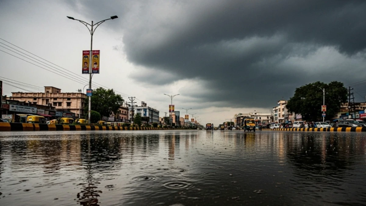
Continuous rainfall soaked Delhi and nearby regions on Monday morning, marking a strong comeback of the monsoon after a prolonged dry spell.
, accompanied by gusty winds and light thunderstorms, were reported across Delhi, Gurgaon, Noida, Ghaziabad and Faridabad, bringing much-needed respite from the recent spell of intense heat.
While the monsoon arrived ahead of schedule for Delhi, the region experienced only scattered rains for nearly ten days. However, meteorological conditions have now aligned to bring substantial rainfall across Delhi and NCR.
The India Meteorological Department (IMD) has issued an .warning of continued heavy rainfall through the day. According to the weather department, the monsoon axis has shifted northward, creating conditions favorable for at least two more significant rain spells over the next four days.
“Scattered moderate to heavy rains with thunderstorms will occur in Ghaziabad, Faridabad, Noida, Palwal, Gurgaon, Baghpat, Parts of Delhi, East Delhi, Jhajjar and nearby areas in the next 2 hours as the axis will shift south once again,” the wweather agency said in a post on X.
The primary reason for this change is the northward shift of the monsoon trough, which is currently positioned over Northern India. This trough is actively drawing moisture from the Arabian Sea, fueling heavier precipitation. Additionally, an approaching Western Disturbance (WD) trough dipping over the region is expected to intensify weather activity, triggering large-scale heavy rains and thunderstorm events.
The downpour this morning caused severe waterlogging and subsequent traffic congestion in several localities of the Capital city. The residents of Sangam Vihar faced major disruptions as the MB Road was submerged under rainwater, leading to long traffic jams and delays for office-goers.
Waterlogging was also reported in East Delhi regions including Akshardham. Commuters expressed frustration and blamed poor drainage infrastructure for the chaos.
Earlier, the regional metrological department, New Delhi, had issued a yellow alert for the national capital today, which was later updated to an orange alert. Notably, the metrological department has predicted light rainfall throughout this week, until July 12.
Meanwhile, Delhi’s air quality continued its remarkable improvement on Sunday, with the Air Quality Index (AQI) remaining in the ‘satisfactory’ category for the 11th straight day, the longest such stretch recorded in 2024 so far. As per data from the Central Pollution Control Board (CPCB), the AQI stood at 76 at 4 pm on Sunday.
The cleaner air trend began on June 26, when the AQI dropped to 94 from 134 a day earlier, shifting from the ‘moderate’ to ‘satisfactory’ category. Since then, Delhi’s air has consistently stayed below the 100 mark, signaling a significant temporary respite from the usual pollution levels.
HEAVY RAIN PREDICTED FOR PUNJAB, HIMACHAL, J&K
Additionally, the India Meteorological Department (IMD) has issued a high-alert weather warning for Northwest India, predicting widespread heavy rainfall, thunderstorms and gusty winds across multiple states.
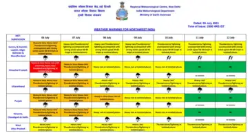
Himachal Pradesh is likely to experience heavy to very heavy rain, with the possibility of extremely heavy rainfall at isolated locations. Similar conditions are forecast for parts of Jammu & Kashmir and Uttarakhand, where intense showers are expected to persist over the coming days.
Heavy to very heavy rainfall is also anticipated in Punjab, Haryana, and Chandigarh, while isolated areas in Uttar Pradesh and eastern Rajasthan may see intense downpours.