A 6.3-magnitude earthquake struck eastern Afghanistan near Jalalabad, killing over 620 people and injuring thousands. Worst hit were Kunar and Nangarhar provinces, where homes collapsed. Tremors were felt in Pakistan, India.
At least 622 people have been confirmed dead after a powerful earthquake struck eastern Afghanistan, according to the Taliban-run Interior Ministry, as reported by Reuters. Over 1,500 have been injured, with rescue operations continuing in remote, badly hit mountain districts. The earthquake was strongly felt across Kunar, Nangarhar and nearby eastern provinces, as well as parts of Pakistan. Officials warned that the toll could rise further as information comes in from remote and mountainous areas.
Scroll to load tweet…
Scroll to load tweet…
Scroll to load tweet…
Epicentre and magnitude
The quake measured 6.3 on the Richter scale, according to both Afghanistan’s authorities and international monitoring agencies. The epicentre was located about 27 kilometres east-northeast of Jalalabad, a major city of nearly 200,000 people. The US Geological Survey reported that the quake struck at a shallow depth of about 8-10 km, which made it especially destructive. India’s National Centre for Seismology (NCS) recorded the event at 00:47:41 IST, with coordinates 34.50°N and 70.81°E.
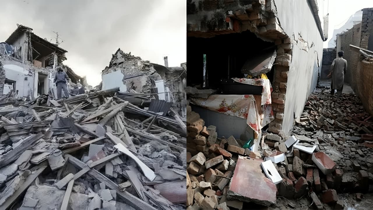
Heavy losses in Kunar and Nangarhar
Local officials said the worst damage occurred in Kunar province, where most deaths have been reported. In Nangarhar, at least nine people were confirmed dead, and hundreds were injured. Sediqullah Quraishi Badloon, a communications officer for Nangarhar, said many of the casualties came from villages where mud and stone homes collapsed quickly. Health minister Sharafat Zaman said rescue teams were still on-site but struggling to access affected areas due to difficult terrain.
Scroll to load tweet…
Scroll to load tweet…
Aftershocks and widespread damage
After the first 6.3-magnitude earthquake that struck eastern Afghanistan, the region was shaken by several aftershocks, causing fresh panic among residents. According to the National Centre for Seismology (NCS), these tremors ranged between magnitude 4 and 5.
The first aftershock measured 4.7 on the Richter scale and occurred at a depth of 140 km, close to the epicentre of the main quake. NCS reported it at 01:08 am IST on September 1. Soon after, another tremor of 4.3 magnitude was recorded at a similar depth of 140 km. The strongest aftershock measured 5.0 magnitude and struck at a much shallower depth of 40 km at around 03:03 am IST.
Experts say these tremors are classified as either shallow or intermediate earthquakes, depending on their depth. Such quakes are usually more dangerous than deep ones because their seismic waves have less distance to travel before hitting the surface. This makes the ground shaking more intense, causing greater damage to buildings and higher chances of casualties.
Afghanistan is especially vulnerable to earthquakes. The country lies on several fault lines between the Indian and Eurasian tectonic plates. The Hindu Kush mountains are one of the most active earthquake zones in the world, and quakes occur there almost every year. A major fault line also cuts directly through Herat, making many Afghan provinces prone to repeated seismic disasters.
Homes and shops collapsed in several districts, while in Jalalabad, buildings shook violently for several seconds. Families fled into the streets during the night, fearing more collapses. Local media reported that several children died when their home’s roof caved in. Hospitals in Kunar and Nangarhar were overwhelmed with injured survivors, and dozens were being transferred to larger facilities.
Tremors felt in Pakistan
The quake’s impact was not limited to Afghanistan. Tremors were felt in Pakistan’s Khyber Pakhtunkhwa province, as well as in the capital Islamabad, located nearly 370 km from the epicentre. While no major damage was reported in Pakistan, the shaking triggered alarm among residents.
Afghanistan’s earthquake vulnerability
Earthquakes are a regular disaster in Afghanistan, where the population often lives in fragile houses built from mud and stone. The country sits on the boundary of the Eurasian and Indian tectonic plates, particularly near the Hindu Kush region, one of the world’s most active earthquake zones. Each new disaster adds to the burden of a country already struggling with decades of conflict, weak infrastructure, and limited emergency resources.
(With inputs from agencies)