
People are layering up in Delhi again as the weather saw a sudden turn this week while the city was approaching the summer season, with rain, brought by a “rare” western disturbance, lashing parts of the city as well as its adjoining areas of Uttar Pradesh’s Ghaziabad, Noida, Haryana’s Faridabad and Gurugram.
The sudden change in weather, that intensified from Wednesday evening, is due to a western disturbance is triggered by an active western disturbance impacting northwest India and keeping temperatures in Delhi several notches below average.
Delhi-NCR on Friday also woke up to rainfall and a yellow-coloured warning as the minimum temperature settled at 16 degrees Celsius, 4.5 below normal, according to the India Meteorological Department’s (IMD) readings from the Safdarjung weather station.
Scattered showers and strong winds kept the cool capital on Thursday as well, with the maximum temperature dipping below 30 degrees Celsius for the first time in nearly a month to 26.8 degrees Celsius, according to the IMD. This was 4.7 degrees below normal and the lowest maximum in Delhi since February 24, when it was 29.9 degrees Celsius.
‘Most intense…’: What experts said on Delhi weather
Weather experts described the weather system bringing rain over North India as rare, giving more details on the unusual nature of this system. “An unusual Western Disturbance has reached North India. Its structure is quite different. A trough is situated in a straight line spanning thousands of kilometers, which is generally very rare. It has the capacity to create very strong thunderstorms and thunderclouds, so be cautious and follow IMD,” said Dr. Pradeep, who describes himself as a climate scientist, on X on Thursday.
Amateur weather expert Navdeep Dahiya, said in a post on X on Friday morning that the “western disturbance under complete intensification”, predicting cold day conditions in some places.
“Western disturbance under complete intensification now! On & off spell of moderate to heavy rains likely in Delhi NCR Haryana Chandigarh till evening hours. Watch for water logging in low lying patches. Coldday conditions likely,” he said in his post.
Heavy rains and thunderstorms to shift in the interiors of Uttar Pradesh from noon onwards, he said, adding that Lucknow and Kanpur will be among the cities likely to be impacted as a result.
Dr Pradeep said on Friday morning on X that the next 6-8 hours are critical for North India and added that the “most intense trough line” of the weather system was “very close to north India”.
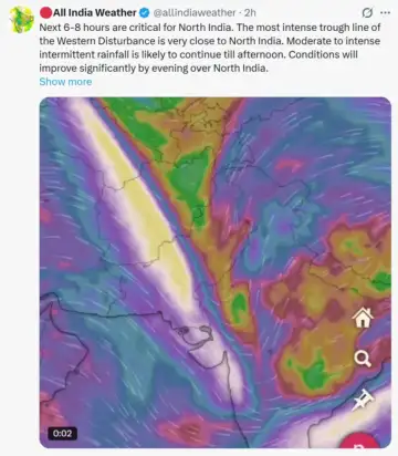 “The most intense trough line of the Western Disturbance is very close to North India. Moderate to intense intermittent rainfall is likely to continue till afternoon. Conditions will improve significantly by evening over North India. Note that rainfall will increase over East India,” he said in the post.
Another X user who described himself as passionate weather and environmental enthusiast shared satellite imagery capturing the system and said he has not seen a more massive western disturbance in his life, calling the coverage of it “insane”.
“I haven’t seen a more massive WD system in my life. Insane coverage..Though activities will shift eastwards by late afternoon however more systems are on the way around 23rd and 28th March though their intensities have to be seen,” the user, Professor RV, said.
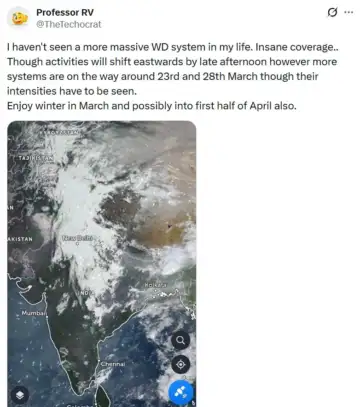 “Enjoy winter in March and possibly into first half of April also,” he said.
Relief temporary, says IMD
Weather forecasts show this respite from early February heat is temporary, with the maximum set to rise again from Friday as the impact of this prevailing western disturbance fades away, HT reported earlier.
“Some scattered very light rain was recorded in the city. Since the western disturbance was feeble, it will not do much in terms of impacting the temperature, which will again start to rise from Thursday and Friday,” the report quoted an IMD official.
The maximum temperature is expected to gradually rise again and touch 31 degrees Celsius by Sunday. It is further forecast to touch 32 degrees Celsius by Monday and Tuesday, making for a warm end to the month.
IMD forecasts show the minimum is likely to hover between 12-14 degrees Celsius from now till the weekend, keeping nights warm too.