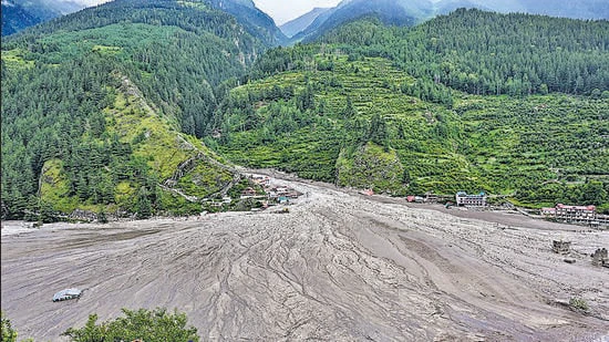
A team from the Indian Institute of Science (IISc) suspects that a “hanging glacier” feeding the Kheer Ganga channel may have contributed to the series of flash floods in Dharali on August 5.
HT reported on August 7 that a preliminary analysis by the National Disaster Management Authority indicated that a glacier collapse may have led to the flash floods.
There are 219 hanging glaciers in the Alaknanda and Bhagirathi basins according to the Divecha Centre for Climate Change at IISc, which, as part of an ongoing study has just completed a geo-spatial mapping of hanging glaciers in Uttarakhand.
A hanging glacier is one that originates high on the wall of a glacier valley and descends only part of the way to the surface of the main glacier.
“Through geospatial analysis, we have mapped all 219 hanging glaciers in the Alaknanda and Bhagirathi basins. We also found that this particular glacier on the Kheer Ganga channel was in a very vulnerable position. In fact there are two hanging glaciers in the vicinity with a combined volume of approximately 1 cubic km. We have historical satellite images of the glaciers. The run-off time during the flash floods was very short. Normally, if flash flood is from rainfall then we can observe a gradual increase and then a decrease. But the sudden run-off points to two probabilities. One that the hanging glacier has fallen, or a lake has formed due to the obstruction of river flow. Then sudden outburst was caused due to overflown,” said Anil Kulkarni, distinguished visiting scientist, Divecha Center for Climate Change, Indian Institute of Science who has been studying the disaster since August 5.
“At IISc we have been doing a lot of modelling exercises to understand which portion of these hanging glaciers is vulnerable to detachment. Hanging glaciers are very sensitive to warming. For these the surface melt starts very early compared to other glaciers and these have been mapped,” added Kulkarni.
The Himalayi Nagarik Drishti Manch has written to the Bhagirathi Eco-Sensitive Zone Monitoring Committee; secretary, ministry of environment, forests and climate change; and the Jal Shakti ministry on Monday seeking accountability for the Dharali disaster. They have referred to a letter by the same civil society organisations sent to the BESZ monitoring committee on April 30, 2024 warning about impending disasters stating that indiscriminate construction on river and hill zones should stop immediately.
The Indian Army has airlifted ground penetrating radar devices from Siachen glacier, even as rescuers in Uttarakhand’s Uttarkashi district are racing against time and digging holes in the muck debris to find missing people. People aware of the matter said the GPRs airlifted from Sichen are in addition to the existing ones that are being used by army personnel and other agencies. The ones brought from Siachen are usually used in cases of avalanches by the defence forces.
Separately, nearly 200 NDRF personnel too are using their own radars and life detection devices to find the people reported missing. Sites where the missing people could be trapped along the 4 km stretch between Dharali and Harshil have been divided by the state disaster management authority(SDMA) and allocated to different teams/agencies.
Over the weekend, NDRF Delhi headquarters also sent two more ground penetrating radar devices to the team on the ground. “There are mountains of muck debris at the site. Some buildings as tall as 2-3 storeys are totally buried in the mud debris. The rescue and search work there involves manually digging at places identified as locals and eyewitnesses. We hope to make progress,” a senior NDRF officer said.