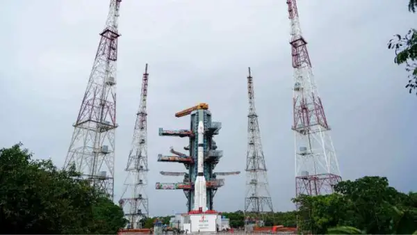
India has taken another step towards bolstering its self-reliant satellite navigation system. The Indian Space Research Organisation (ISRO) successfully put into orbit its next-generation navigation satellite, NVS-03, aboard the GSLV-F18 rocket on Friday night (October 30)
The 50-metre-tall Geosynchronous Satellite Launch Vehicle (GSLV) took off at 11:51 pm at the Satish Dhawan Space Centre at Sriharikota in Andhra Pradesh. The rocket has successfully launched the 2,232-kg satellite into its targeted Geosynchronous Transfer Orbit (GTO), which is the 20th flight of the GSLV.
The mission holds importance for India’s navigation system, an indigenous alternative to the US-operated GPS, called Navigation with Indian Constellation (NavIC). NVS-03 is the third satellite of ISRO’s second-generation navigation satellites, which has been designed as a continuity satellite for navigation services with enhancement of its capabilities.
Why is ISRO’s NVS-03 Satellite significant?
The indigenous atomic clock technology coupled with an extra navigation frequency is one of the critical aspects of NVS-03.
The satellite has an Indian-built atomic clock as well as retrieved atomic clocks on board. It is also launching the L1 band signal along with NavIC’s current NavIC’s L5 band and S-band signals.
The additions are significant because satellite navigation requires very accurate time and the capability of a receiver to receive navigation signals.
The L1 frequency is of special interest for civilian applications. It is very common in satellite navigation receivers, including those found in consumer devices. This feature may make NavIC more compatible with a wide variety of navigation devices.
This may pave the way for more people to use India’s home-grown navigation system in other specialist applications.
How is NVS-03 going to enhance the NavIC system?
NavIC or Indian Regional Navigation Satellite System (IRNSS) is India’s own satellite navigation system which is designed to provide an independent regional satellite navigation system, developed by ISRO.
The system offers Position, Navigation and Timing (PNT) services over India’s national territory and about 1500kms beyond the country’s geopolitical borders.
NavIC is developed and maintained by India, unlike GPS which is operated by the United States. It is designed to serve civilian and strategic needs in an independent navigation system.
The system can be used in various fields such as:
- Transportation: Monitoring of road vehicles and other transportation systems, such as trains.
- Maritime operations: Providing assistance to navigation and tracking of ships and fishing boats.
- Disaster Management: Emergency response and relief positioning information.
- Telecommunications: Applications that depend on time synchronisation.
- Location-based services: Providing navigation and positioning, with the help of compatible devices.
- The introduction of NVS-03 will be used to reinforce continuity and availability of these services.
Why does NVS-03 have an Indigenous Atomic Clock?
One of the most crucial parts of a satellite navigation system is an atomic clock.
Navigation satellites continuously broadcast information relating to time. On the ground, receivers can measure the time satellites take to reach them and use these measurements to determine their distance.
The positioning calculations can be affected by even a small mistake in measurement of time.
NVS-03 is equipped with an indigenous atomic clock built in India, as well as procured atomic clocks. The technology is significant for the ability to decrease reliance on imported parts and components for critical navigation infrastructure.
The development of such technology is important for India as it also has applications for several communication and infrastructure setups apart from navigation.
What happens next?
ISRO’s NVS-03 has been successfully put into its intended transfer orbit, but the satellite needs to undertake a few more orbit manoeuvres before it reaches its intended spot.
The satellite was put into an orbit that was to have a perigee of some 170 kilometres and an apogee of 37,023 kilometres.
It will gradually use its onboard propulsion system to attain its intended geosynchronous orbital plane 32.5 degrees East.
ISRO will conduct various in-orbit tests and commissioning activities before the satellite can offer navigation services.
It is important to note that launch and orbital injection do not necessarily imply operational status.
GSLV-F18 has successfully completed its 20th mission
This is also the 20th flight of India’s Geosynchronous Satellite Launch Vehicle (GSLV) during the NVS-03 mission.
The three-stage rocket is a crucial component of the Indian space launch programme, especially for the launch of heavier satellites into geosynchronous transfer orbit.
ISRO also mentioned that it had achieved a 56-day gap between the missions of GSLV, which showcases the progress made in preparation and operational efficiency.
The space agency attributes all its successes to the contributions of its scientists, industrial partners and academic institutions. Domestic industries have also been doing their part, he added, noting that almost 80 per cent of the mission funds have been devoted to industries in the country.
What does the NVS-03 mission mean for India’s space programme?
The successful launch of NVS-03 is not just another addition to India’s satellite fleet. It forms part of a wider initiative to ensure the nation’s key Space-based infrastructure is under more effective control.
Satellite-based services have become vital for modern economies, in terms of navigation and transportation, communication, precision timing, and more.
This would allow India to be more self-reliant in these aspects and enhance the availability of indigenous navigation services with the help of a robust NavIC constellation.
The L1 signal and local atomic clocks feature in the mission’s scope of activities that extend beyond the launch.
India now aims to reach its operational commissioning soon after the launch of NVS-03, and their performance will be closely monitored during the process as they pursue self-reliant satellite navigation technology.